
The UK Met Office has issued a severe weather warning for next week as two Hurricanes look set to merge into one ‘superstorm’ and wreak havoc across Britain.

Destructive winds, and devastating floods are expected to ravage large parts of the United Kingdom on Monday, when Hurricane Brian strikes.
Power and transport networks are expecting cancellations, which will likely cost UK businesses billions.
![]()
BYPASS THE CENSORS
Sign up to get unfiltered news delivered straight to your inbox.
You can unsubscribe any time. By subscribing you agree to our Terms of Use
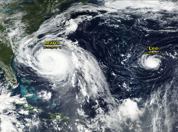
Express.co.uk reports:Both Hurricanes are currently at Category One strength as they make their way across the Atlantic. Latest GFS tracks released this morning show the projected path of the newly formed storm hitting the UK early next week.
VIP Child Pimp Found Dead After Revealing 'Epstein is Alive and Blackmailing US Politicians'
Meteorologists fear an extremely violent post-tropical cyclone – Storm Brian – will form and head straight for the UK.
The current projected path of Storm Brian – as it will be called if it severely threatens the UK – shows it making landfall next Monday, with the churning vortex smashing first into Ireland, then mainland Britain.
Britons should brace themselves for “a bang” according to experts who warn the nation faces “significant” disruption.
Jim Dale, forecaster for British Weather Services, said megastorm caused by Maria and Lee coming together could give rise to the UK’s second named storm of the season.
He said: “Both hurricanes are located around the northeast coast of America but we expect them to get together around Sunday.
“The jet stream is powering up and as it swings southwards towards the end of the week it will help steer the remnants of these storms towards us.
“Both of these are powerful systems and when they get caught up in the jet stream they could be given more life.”
Meteorologists are keeping a very close eye on developments over ocean waters and the track of the jet stream over the next few days.
Mr Dale added: “We do have the potential for major winds next week. A significant October storm is not out of the question.
“It is likely we will see severe gales, perhaps not right across the whole country, but certainly one to watch.”
Hurricane Lee and Maria are expected to join early on Thursday before hurtling across the Atlantic towards the UK.
The US National Hurricane Center issued a revised forecast warning that Hurricane Maria would turn east-northeastward towards Britain – and Lee – and accelerate within 48 hours.
It said hurricane-force winds currently extend outward up to 105 miles from the centre of Maria and tropical-storm-force winds up to 240 miles. Lee is smaller, with a hurricane force wind field of 15 miles and tropical-storm-force winds extending outward up to 45 miles.
It’s latest forecast warned that Lee remains a “small but impressive” hurricane with a well-defined eye on visible satellite images.
It said: “Further strengthening is possible for the next day or so while Lee continues moving over warm waters.
“Most of the guidance shows Lee getting a bit stronger, and the cyclone stands some chance of becoming a major hurricane within the next 24 hours or so.
“Later this week Lee should become absorbed [by Maria] in a large extratropical low over the northeastern Atlantic Ocean.”
Lee and Maria are currently causing 75 to 105mph in the Atlantic. Latest ECM TC tracks also show both hurricanes are expected to head East North East.
WX Charts tweeted: “The GFS again showing remnants of #Maria and #Lee combining with an extra-tropical low and heading towards the British Isles by Sunday.”
Weather forecaster Jim Cantore said: “Lee is firing up and trying to meet up with Maria before they both take off for a trip and transition on the way to Europe.”
Maria and Lee are expected to make an extratropical transition by combining with low pressure in the Atlantic later heading toward the UK by Sunday.
Maria is still much bigger in size than Lee despite both being Category One hurricanes however wind speeds are at similar levels in both.
Both are forecast to make an abrupt northeastwards turn later this week before Maria engulfs Lee to form a new, major storm.
This will give rise to one deep low pressure system which, helped by the jet stream, will then hurtle towards the west coast of Britain.
Eleanor Bell, forecaster for The Weather Company, said: “We expect Maria to curve back over the Atlantic before joining with Lee and forming one deep low pressure system.
“The latest models are showing a significant low moving across the UK next Monday bringing some very wet and windy conditions.
“It is going be a very unsettled period of weather for the UK.
“It is difficult at this early stage to say where will see the most impact, and while everywhere is likely to see something, we think the north and the west will be most unsettled.
“Nowhere is really going to escape the wind and rain, and we are looking at gale-force winds.”
The impact from Monday’s assault threatens to unleash a worse assault than Storm Aileen which struck mid-September.
While there was some disruption including loss of power and transport delays, the impact was less severe than first thought.
It will be a shock to the system to many in the UK after the relatively calm, settled and unusually warm start to autumn.
While stirring up gales this side of the Atlantic, the remnants of the storms will also drag a swath of warm air across the UK.
Temperatures are expected to start creeping up at the beginning of next week although it will feel cool in the wind and rain, experts say.
Worrying forecasting models project the storm system rapidly deepening before hitting the west coast of Britain next Monday.
Brian will be named as the second storm of the season if the likely impacts are deemed by the Met Office to be severe enough.
Britain and the US have separate systems for naming autumn storms, so when Maria and Lee reach the UK as one storm they will be re-named Brian.
The Met Office said with one week to ago before the remnants of both system are due to hit the UK, the impact is still uncertain.
Spokesman Grahame Madge said: “Some of the model outputs are suggesting the hurricanes may merge to form a new depression in the Atlantic.
“There are also various predictions of the track it will take, so there is still much uncertainty at this stage.”
He added: “However, if the two systems merge, they will bring air of tropical origin into the north Atlantic giving energy to low pressure systems closer to the UK.
“Putting warm, tropical air into these serves to modify them and this happens there is the potential for rising humidity and winds in the UK.”
Britain’s largely settled weather over the past few weeks has been driven by a huge area of high pressure stretching across Europe from Russia.
This is expected to start weakening over the next few days opening the doors to stormy conditions from the Atlantic.