
Scientists measuring the risk of severe earthquakes that could bring havoc to southern California warn of the dangers of the San Andreas and San Jacinto faults rupturing together.
Data suggests that they may have ruptured together in the past leading scientists to call for a risk assessment review.

The Guardian reports:
The warning follows latest research from a US geologist who found that two large faults in the region – the San Andreas and the neighbouring San Jacinto fault to its south – might have ruptured together in the past, producing an earthquake that caused damage as far north as San Buenaventura and was felt as south as San Diego.
![]()
BYPASS THE CENSORS
Sign up to get unfiltered news delivered straight to your inbox.
You can unsubscribe any time. By subscribing you agree to our Terms of Use
“Looking at old earthquakes in general is really a good way to figure out what faults are capable of doing,” said Julian Lozos, assistant professor of geophysics, California State University, Northridge, who conducted the research.
Wendy Williams Leaks Tape Showing 'Cannibal' Ellen DeGeneres Feasting on Black 'Child Meat'
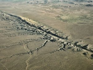
Forming the boundary between two plates of Earth’s crust, the San Andreas fault runs for around 800 miles (1,300km) through the state of California with its southern section neighbouring the San Jacinto fault.
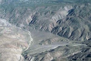
However while the San Jacinto fault is know to be active, and has experienced several earthquakes between magnitude 6 and 7 in the last 120 years, Lozos’s research suggests a simultaneous rupture with the San Andreas fault could have resulted in a more powerful earthquake of around magnitude 7.5.
Using computer models to explore an earthquake that struck southern California in 1812, Lozos found that the earthquake most likely began on the San Jacinto fault near Mystic Lake, travelled north and then ”jumped” to the San Andreas fault.
A similar scenario today, he warned, could be devastating. “San Jacinto goes through a lot more city that the San Andreas does – or it goes closer,” he said. “The San Andreas is certainly capable of having a 7.5 [magnitude earthquake] by itself. But the San Andreas and San Jacinto [together] then brings that earthquake closer to more people,” he added.
Others have also been quick to seize on the ramifications of the study. “The preponderance of evidence is that they did rupture jointly and that is really important in terms of how we plan for earthquakes because a lot of our planning has been based on the assumption that it was either the San Andreas or the San Jacinto but not the two together,” saidProf Lisa Grant Ludwig, from University of California Irvine.
ProfFred Pollitz from the United States Geological Survey (USGS) also believes the possibility of a multi-fault rupture is significant. “This is important because the size of a multi-segment rupture can be much larger than the size of a single-segment rupture, ie. one restricted to say just the San Andreas fault,” he said.
Published in the journal Scientific Advances, the new study focuses on a large earthquake that struck Southern California on 8 December 1812. Thought to be around magnitude 7.5, the event caused widespread damage, with around 40 people killed as the church buildings of the Mission of San Juan Capistrano crumbled.
But unpicking the mystery of exactly what happened has been a challenge. With no scientific observations from the time to go on, geologists at first believed the earthquake had occurred on a fault known as the Newport-Inglewood fault before analysis of tree-rings led scientists to believe that the earthquake had occurred along the San Andreas fault instead. Further evidence suggested that an earthquake had occurred further south, on the northern section of the San Jacinto fault, at a similar time. Recent research meanwhile by Ludwig, Lozos and others into precariously balanced rocks – large lumps of stone that have remained untoppled by earthquakes – also hinted that the two faults could have ruptured simultaneously.
New computer modelling by Lozos not only suggests that the two faults did indeed rupture together, but also provides new insights into the path of the earthquake. “It provides an alternative model for how the 1812 earthquake occurred, and that changes our view of how the San Andreas – San Jacinto fault system might work,” explained Prof Kenneth Hudnut from the USGS.
Using data relating to the geology of the faults, their geometry and the stresses they experience, Lozos constructed a model for the San Andreas system which allowed him to explore what would happen if an earthquake had been triggered at four different locations. By comparing the results with reported damage from historical records, the locations of precariously balanced rocks and evidence of earthquakes gleaned from trenches dug across the faults – so-called paleoseismic data – he found that the 8 December 1812 earthquake most likely began in the Mystic Lake region of the San Jacinto fault in before travelling north and “jumping” across to the San Andreas fault.
“If you have got a friend that is stressed out and loses it, that is probably going to stress out their friends,” explains Lozos. “It is the same idea with faults. Faults are accumulating stress at different rates, they have different frictional thresholds. And the closer they are together the more likely they are to influence each other.” The upshot he says is that “sometimes the stress change from an earthquake – especially a pretty big earthquake – on a nearby fault might be enough to just overcome the frictional threshold and get that fault flipping.”